
UN backs ‘Correct the Map’ campaign as 164 nations vote for a truer representation of Africa
Jamaica Live International News– | Sept 5, 2026
United States casts the only vote against historic African-led resolution challenging centuries of distorted world maps.
For generations, millions of schoolchildren have grown up looking at a world map on which Africa appears considerably smaller than its true geographical size.
Now, the United Nations General Assembly has overwhelmingly backed an African-led effort to change that.
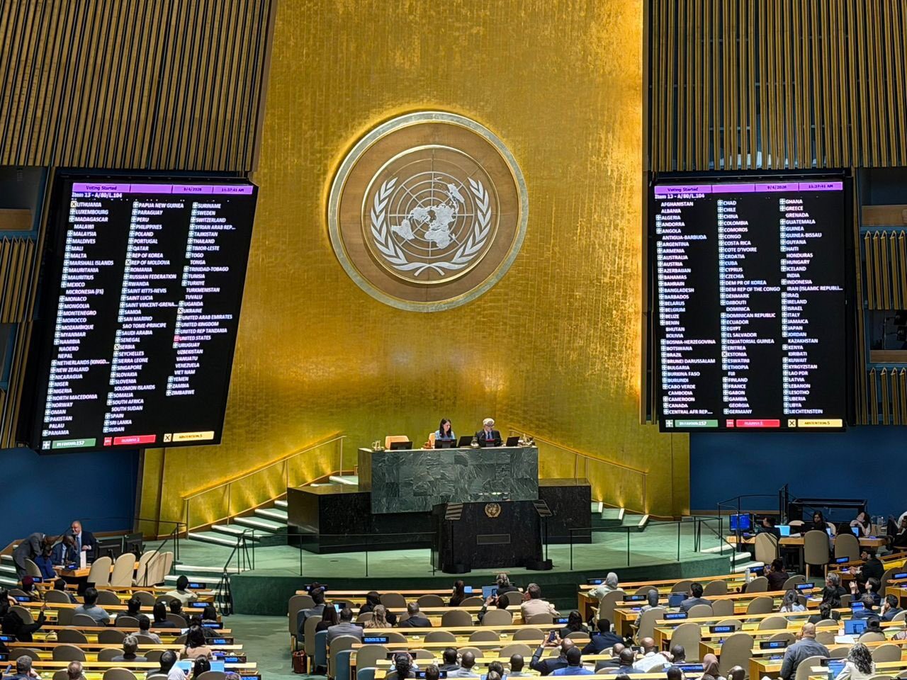
On Friday, September 4, the General Assembly adopted a landmark resolution encouraging wider use of map projections that accurately preserve the relative sizes of continents and countries, particularly the Equal Earth projection.
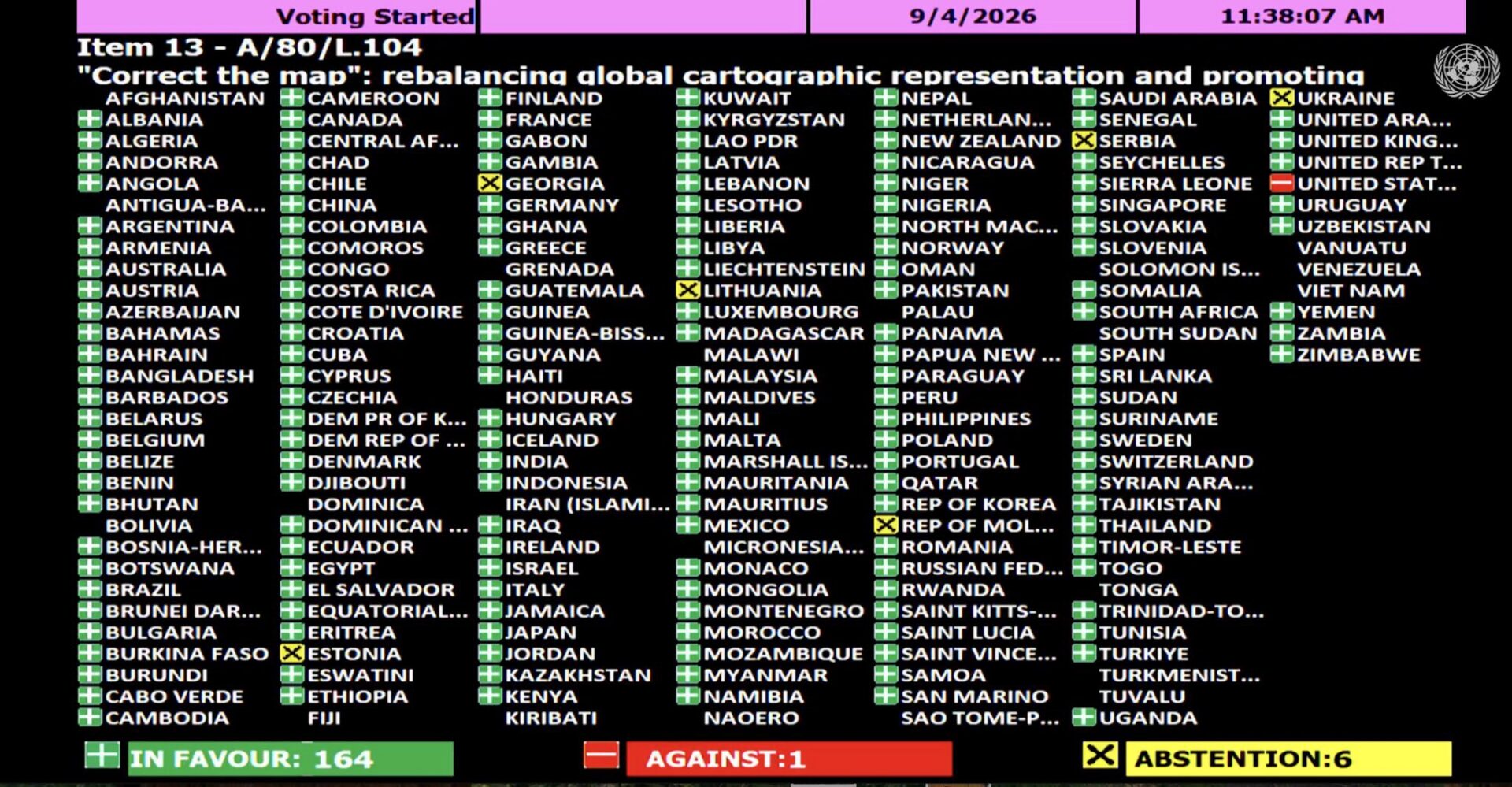
The resolution — “Correct the map: rebalancing global cartographic representation and promoting equitable representation of the world’s regions, particularly Africa” (A/80/L.104) — was adopted by an extraordinary 164 votes in favour, one against and six abstentions.
The United States was the only country to vote against the resolution.
The six countries abstaining were Estonia, Georgia, Lithuania, the Republic of Moldova, Serbia and Ukraine, according to the official United Nations meeting record.
The vote represents a major diplomatic victory for Togo, which championed the initiative on behalf of African states, and for the wider African-backed “Correct the Map” movement.
But supporters insist that the campaign is about considerably more than changing the picture hanging on a classroom wall.
It is about changing how the world sees Africa.
Africa has not been physically small — it has been mapped small
At the heart of the controversy is the Mercator projection, created by Flemish cartographer Gerardus Mercator in 1569, during the slave trade.
Mercator was designed primarily to solve a navigational problem. Its geometry made it exceptionally useful to sailors because lines of constant compass bearing could be represented conveniently on a flat map.
The problem arises when a projection designed for navigation becomes the familiar visual representation of the political world.
No flat map can perfectly reproduce a spherical planet. Every projection must distort something — shape, distance, direction or area.
Mercator preserves direction and local shapes particularly well but dramatically distorts area, with the distortion increasing towards the poles.
The result is a world that visually exaggerates northern landmasses while reducing the apparent scale of many regions closer to the equator.
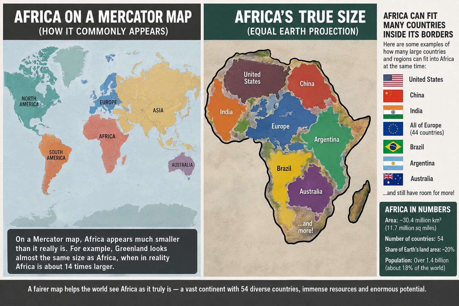
One of the most famous examples is Greenland and Africa.
On many Mercator maps, Greenland can appear comparable in size to the African continent.
It is not.
Africa is approximately 14 times larger than Greenland.
That single comparison illustrates why African governments and campaigners increasingly argue that the familiar world map does not simply contain a technical imperfection — it gives viewers a fundamentally misleading impression of the relative physical scale of different parts of the world.
Enter the Equal Earth map
The UN resolution encourages the use of Equal Earth and other equal-area projections when accurately comparing the sizes of countries and continents is important.
Unlike Mercator, an equal-area projection preserves the relative area of landmasses.
That means a country or continent occupying twice as much actual surface area as another will also occupy twice as much area on the map.
Equal Earth, introduced in 2018, was designed to combine accurate relative area with visually recognisable continental shapes.
The UN resolution describes Equal Earth as a relevant option for improving the accuracy of world cartography and encourages governments, international organisations and other institutions to adopt and disseminate Equal Earth and other equal-area methods.
Importantly, however, the UN has not ordered the world to throw away Mercator maps.
The resolution is non-binding.
Nor does it prohibit Mercator’s continued use for purposes for which it remains particularly effective, including maritime and aerial navigation.
Instead, the resolution addresses the much broader use of Mercator-style maps as representations of the relative physical size of the world’s nations and continents.
Togo: ‘How do we represent the world?’
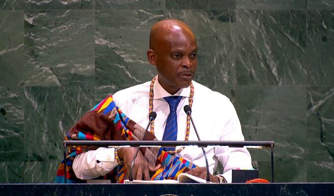
The concept was spear-headed and introduced to the United Nations on behalf of the Group of African States by the representative of Togo, heavily championed by Togo’s Foreign Minister Robert Dussey.
Introducing the resolution on behalf of the Group of African States, Togo’s representative placed the argument firmly within the broader question of historical representation.
The issue, he argued, was not simply which mathematical formula cartographers should use.
It concerned how humanity has been taught to visualise itself.
“How do we represent the world? How do we teach it? How do generations learn to see our planet?” he asked during the General Assembly debate.
Togo argued that maps appearing in textbooks, media, digital platforms and official documents have for generations distorted the relative sizes of continents, with consequences extending beyond geography into education, culture and perceptions of international importance.
The resolution therefore connects cartographic representation with what its supporters describe as historical recognition, equitable representation and cognitive justice.
The argument is straightforward: maps are not merely geographical tools.
They are among the first representations children encounter of the wider world.
They communicate, consciously or unconsciously, ideas of size, position and importance.
And when those representations are repeated across generations, supporters contend, visual distortions can become embedded in the public imagination.
‘A fair map does not change geography’
Togo was also careful to emphasise that the initiative was not an attack on Europe, North America or any particular civilisation.
The campaign does not seek to physically enlarge Africa on maps beyond its actual dimensions.
Rather, it wants Africa — and every other region — shown in correct proportion when area is what the map is intended to communicate.
As Togo’s representative told the Assembly:
“A fair map does not change the geography of the world; it changes how we see the world.”
That distinction is crucial.
Equal Earth does not make Africa bigger.
Africa was always that big.
The projection simply prevents the continent’s enormous geographical scale from being visually compressed relative to northern regions.
Why Africa says the issue is connected to colonial history
The political significance of the campaign lies partly in the historical period during which European-produced maps became globally dominant.
Mercator himself created his projection in the 16th century for navigation, not as a deliberate scheme to diminish Africa.
That distinction matters historically.
But critics argue that the subsequent global dominance of Mercator-style world maps developed alongside centuries of European exploration, colonial expansion and the establishment of Western educational and political institutions.
Over time, a navigational projection became one of the world’s most recognisable mental images of geography.
African advocates therefore distinguish between the original mathematical purpose of Mercator and the later cultural consequences of repeatedly using that projection to depict the political world.
The UN resolution reflects that broader concern, recognising that historically inherited distortions can have cognitive, educational, cultural, geopolitical and socioeconomic effects.
The United States stands alone
Perhaps the most striking political aspect of Friday’s vote was not simply the overwhelming support for the resolution.
It was the isolation of the United States.
Washington cast the only “no” vote among UN member states participating in the recorded vote.
The United States argued that the General Assembly was devoting its attention to an ideological issue rather than more urgent international problems.
US representative Yaryna Ferencevych characterised the initiative as part of what Washington regarded as a broader ideological agenda and argued that the UN should concentrate on substantive questions of international peace, prosperity and relations between nations.
That objection failed to persuade the overwhelming majority of the Assembly.
The final tally was:
164 — Yes
1 — No
6 — Abstentions
The six abstaining countries were Estonia, Georgia, Lithuania, Moldova, Serbia and Ukraine.
Russia backs the African position
Russia, by contrast, supported the resolution and framed its vote within Moscow’s broader opposition to what it describes as the continuing legacy of colonialism and neo-colonialism.
During the General Assembly discussion, the Russian representative expressed support for African states’ efforts to address historical inequities and strengthen Africa’s position within what Moscow describes as an increasingly multipolar international order.
The debate therefore demonstrated how an apparently technical question about cartography can intersect with some of the world’s largest political arguments: colonial history, global power, education, representation and the changing influence of the Global South.
Togo intends to start in its own classrooms
Togo is not treating the resolution merely as a symbolic diplomatic victory.
Foreign Minister Robert Dussey told Reuters that his country intends to change its own geography materials and hopes to begin introducing the new approach in schools by the end of 2026.
“Togo will be the first country to change our own geography books,” Dussey said.
The government also intends to work with other African Union states and supporters elsewhere to encourage wider adoption among governments, schools, international organisations and technology companies.
That could ultimately prove more significant than the General Assembly resolution itself.
Because the resolution is non-binding, its long-term impact will depend on what happens next — particularly whether education ministries, publishers, news organisations, international institutions and digital mapping companies change the projections they use.
What this means for Jamaica and the Caribbean
Although the campaign has understandably centred Africa, the underlying issue has relevance far beyond the African continent.
For Jamaica and the wider Caribbean, the debate raises important questions about how geography, colonial history and global power are taught in schools.
Jamaica’s history cannot be separated from Africa.
The majority of Jamaicans descend principally from Africans brought across the Atlantic during European slavery and colonial rule. African geography, history and civilisation are therefore not remote subjects for the Jamaican classroom; they form an essential part of understanding Jamaica’s own historical development.
If generations of Jamaican children have viewed Africa through maps that substantially understate its physical scale relative to Europe and northern regions, the question raised by the UN initiative becomes relevant here as well:
What image of the world should Caribbean children inherit?
This does not mean replacing one distortion with another.
It means understanding what different maps actually show.
Students could be taught why Mercator was revolutionary and remains useful for navigation, while simultaneously learning why an equal-area projection is preferable when comparing the physical sizes of countries and continents.
That approach would turn the controversy into an opportunity for stronger geographical education rather than simply another political argument.
Maps influence the way people imagine power
The deeper argument behind “Correct the Map” is psychological.
People rarely walk around thinking mathematically about continental surface areas.
Instead, much of our understanding of the world is visual.
We remember where countries appear on maps, which regions look enormous, which appear tiny and which seem to dominate the globe.
Those impressions can become part of what scholars call our mental map of the world.
A map cannot create economic, military or political power.
But it can influence perceptions.
If one group of countries repeatedly appears enormous while another region appears substantially smaller than its actual relative size, advocates argue that those visual impressions matter — particularly when reproduced across textbooks, television studios, government offices and digital platforms for generations.
That is why supporters reject the suggestion that this is merely an argument over cartography.
To them, it concerns the relationship between knowledge and power.
Africa’s actual scale is enormous
The debate has also prompted renewed attention to just how large Africa actually is.
The continent covers roughly 30 million square kilometres.
Yet the familiar Mercator representation can make northern countries and regions look disproportionately large beside it.
This is not because Mercator singles Africa out. It is a mathematical consequence of the projection: landmasses become increasingly enlarged the farther they are from the equator.
That is why Greenland, Canada, Russia and northern Europe can appear extraordinarily large.
The distortion works geographically, not racially or politically.
But the social consequences of choosing that projection as the standard political world map are precisely what African campaigners are asking the international community to reconsider.
Not erasing Mercator — understanding its limitations
The UN decision should therefore not be interpreted as declaring that the Mercator projection is “false” in every application.
Mercator solved an important cartographic problem and has remained useful for centuries precisely because of its navigational properties.
The issue is using the right map for the right purpose.
If the purpose is navigation, Mercator has important advantages.
If the purpose is comparing the actual territorial size of Africa with Greenland, Europe, North America or any other region, Mercator is highly misleading.
Equal Earth prioritises area accuracy, giving viewers a much better sense of how much of Earth’s surface different countries and continents actually occupy.
That distinction is at the heart of the resolution.
A symbolic victory with potentially practical consequences
Friday’s vote does not instantly change every atlas, classroom or online mapping service.
It does not redraw international borders.
It does not make Equal Earth compulsory.
And it certainly does not alter the physical geography of the planet.
What it does is give powerful international legitimacy to a question African scholars, governments and activists have increasingly raised:
Why should a map designed for 16th-century European maritime navigation continue to shape how 21st-century children visualise the relative size of the world’s continents?
The General Assembly’s answer, by 164 votes to one, was that alternatives deserve much wider use.
For Africa, the decision carries enormous symbolism.
For centuries, the continent has fought against narratives imposed from outside — narratives concerning its history, civilisation, economic importance, political capacity and place within the international system.
Now that conversation has reached something even more fundamental:
the map itself.
Togo’s message to the General Assembly was ultimately simple. Correcting the map does not require making Africa larger.
It requires allowing the world to see how large Africa has always been.
And after Friday’s overwhelming vote at the United Nations, that argument has moved from an African campaign into the centre of global diplomacy.
Jamaica Live News
Your trusted news source both locally and internationally.
Sources: United Nations General Assembly meeting records and document A/80/L.104; United Nations meeting schedule; Reuters reporting, September 4, 2026.